Fleet supervision requires more than knowing where each vehicle is. Managers also need to know whether it follows an expected route, reaches planned checkpoints, and remains stopped with ignition active for too long. This ALTAGAMA GPS update added configurable route and checkpoint controls together with a complete set of tools for measuring, displaying, alerting, and reporting idling time.
The functions turn GPS locations and ignition state into operational information. Managers can adapt a route margin to real conditions, define the valid area around a stop, and analyze idling from the map, statistics, activity summary, and reports.
GPS route alerts with configurable width
A route in ALTAGAMA GPS represents an expected path. Its width creates a corridor around the drawn line and determines whether a location is considered inside or outside that path.
Users can now adjust this width when creating or editing a route. A narrow corridor may suit well-defined roads with strong GPS reception, while a wider one can accommodate divided highways, industrial access roads, approved detours, or areas where accuracy varies.
The original release used 400 meters as the default route-width reference. The appropriate value depends on the environment and the operation's tolerance. A margin that is too narrow can produce notifications from small position variations; one that is too wide can hide meaningful deviations.
Route width demonstration
The original video shows how the corridor around a route is adjusted visually.
Checkpoints with a custom radius
A checkpoint is a place a vehicle should reach or pass, such as a warehouse, customer, station, toll, yard, or delivery area. The radius determines how close a location must be before the device is considered inside the checkpoint area.
The radius can be configured for site size and expected accuracy. The original release presented 200 meters as the default reference. A large yard may need broader coverage, while a specific urban stop may use a smaller radius after testing.
Customization improves alerts by matching the rule to the real site. Before production use, drive through the location, review several positions, and confirm that entry and exit are detected at the expected time.
Checkpoint radius demonstration
The following original video shows the visual adjustment of the area around a checkpoint.
How to choose the right width and radius
- Tracker accuracy: consider whether locations come from GPS and the quality reported by the device.
- Reporting frequency: long intervals can make a vehicle jump across a boundary between messages.
- Site size: a logistics center needs a different radius from a roadside stop.
- Road type: parallel roads, turns, and overpasses may require a more tolerant corridor.
- Alert objective: a critical deviation may need a different rule from an informational check.
Routes and checkpoints do not replace a geofence when an operation needs a complete polygon. Each tool serves a different geometry and use case.
What idling time means in ALTAGAMA GPS
ALTAGAMA GPS calculates idling when a vehicle remains without movement while Sensor 1 is active. In many installations that sensor represents ignition, so the value approximates time during which the vehicle is stopped with ignition on.
Interpretation depends on the installation. If Sensor 1 is connected to another signal, inverted, or reported incorrectly, the result will not represent actual ignition. The installer should test the signal and assign a clear name before using idling as a performance indicator.
Idling time is calculated from received locations. It does not directly measure fuel consumption, emissions, or mechanical engine state. It provides a basis for identifying periods that deserve review.
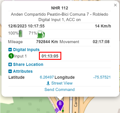
Idling field in vehicle information
The original image shows the new idling value associated with device activity.
Idling time statistics
The new statistic totals accumulated idling by device during the selected period. Managers can compare vehicles, days, or groups and identify units that spend a large portion of the workday stopped with ignition active.
A supervisor can select a branch's delivery fleet, review one week, and direct attention to vehicles with the highest accumulated time. The result should then be compared with routes, authorized stops, and operating conditions to understand the cause.
Idling statistic demonstration
The original video presents the accumulated time query in the statistics section.
Alert for excessive idling time
We added an alert that activates when continuous idling exceeds the configured threshold in minutes. The notification includes the calculated duration to give operators useful context.
This rule helps teams respond while a condition is happening. A company can use a short threshold for vehicles that should not wait with ignition active, or a longer one where normal loading, unloading, or customer service produces expected stops.
Test the threshold with real data before notifying drivers or escalating events. Traffic, queues, maneuvering, and service processes can all create legitimate idling.
Idling alert demonstration
The following original video shows alert configuration and behavior.
Idling visible directly on the map
The map added an hourglass control that displays idling time next to vehicle markers. Operators can see which vehicles have remained stopped longer without opening a separate report.
This current view supports prioritization. A vehicle stopped for a few minutes may be completing a delivery; another far beyond the normal time may indicate unnecessary waiting, congestion, a route issue, or an ignition signal that needs inspection.
Idling beside map markers
The original video shows how idling information is enabled on the map.
Idling in the activity summary
The activity summary now includes total idling for the selected period. Customers can review movement, stopped time, and vehicle use in one place without rebuilding the calculation manually.
This view supports daily analysis and operating meetings. It helps reveal trends, compare the result with working hours, and decide which routes need closer inspection.
Activity summary demonstration
The original demonstration presents the indicator in the activity summary.
Idling variable available in reports
Idling time can be added as a variable in ALTAGAMA GPS reports. It can appear with device, date, route, and other columns available for the selected report type.
A company can prepare a weekly report by vehicle, share it with operations, or use it as evidence when reviewing driving habits. The value is more useful when compared with trip context instead of treated as an isolated number.
Report variable demonstration
The original video shows idling time being added to a report configuration.
Real-world applications for companies and fleets
- Distribution: confirm checkpoint visits and detect extended waits with ignition active.
- Passenger transport: review time at terminals and compliance with expected corridors.
- Field service: verify customer visits and analyze waiting time between jobs.
- Construction: identify equipment or vehicles stopped with an operating signal active.
- Security: receive notifications when an asset leaves an approved route or misses an expected point.
- Sustainability: locate opportunities to reduce idling after validating fuel use and working conditions.
A real-world case: urban delivery with scheduled stops
A distribution fleet creates a daily route with enough width to allow approved parallel streets and configures a checkpoint around each delivery center. Alerts help identify a deviation or confirm arrival in the expected area.
During a delivery, the vehicle may remain stopped. If Sensor 1 correctly represents ignition and time exceeds the selected threshold, ALTAGAMA GPS generates an idling alert. The operator checks the map before contacting the driver to distinguish normal unloading from unnecessary waiting.
At the end of the week, the manager compares statistics and the activity summary, adds the value to a report, and prioritizes routes with the greatest opportunity for improvement.
Benefits for fleet management
- Route alerts adapted to the operating margin of each journey.
- Checkpoints matched to the actual size of yards, customers, and stops.
- Idling visibility across the map, statistics, alerts, summary, and reports.
- Accumulated time comparisons among vehicles and periods.
- Faster response to prolonged stops.
- Data that can guide productivity, fuel, and emissions improvements without confusing an estimate with a direct measurement.
Technical configuration summary
- Route width defines the corridor used to evaluate locations near a path.
- Checkpoint radius determines the entry area around its coordinate.
- The original release presented default references of 400 meters for routes and 200 meters for checkpoints.
- Idling requires no movement and an active Sensor 1.
- The alert compares continuous time with a threshold configured in minutes.
- The statistic calculates accumulated time within the selected period.
- The value is also available on the map, activity summary, and reports.
- Accuracy depends on tracker data, installation, reporting frequency, and location quality.
Explore routes, checkpoints, alerts, statistics, and reports in the ALTAGAMA GPS plans and features.